The islands of Tenerife and Gran Canaria are approaching
The volcanic crisis experienced by the island of Tenerife in 2004 allowed us to observe a geodynamic process parallel to that of the African plate: it provokes an approach with the island of Gran Canaria that could be consummated within millions of years.
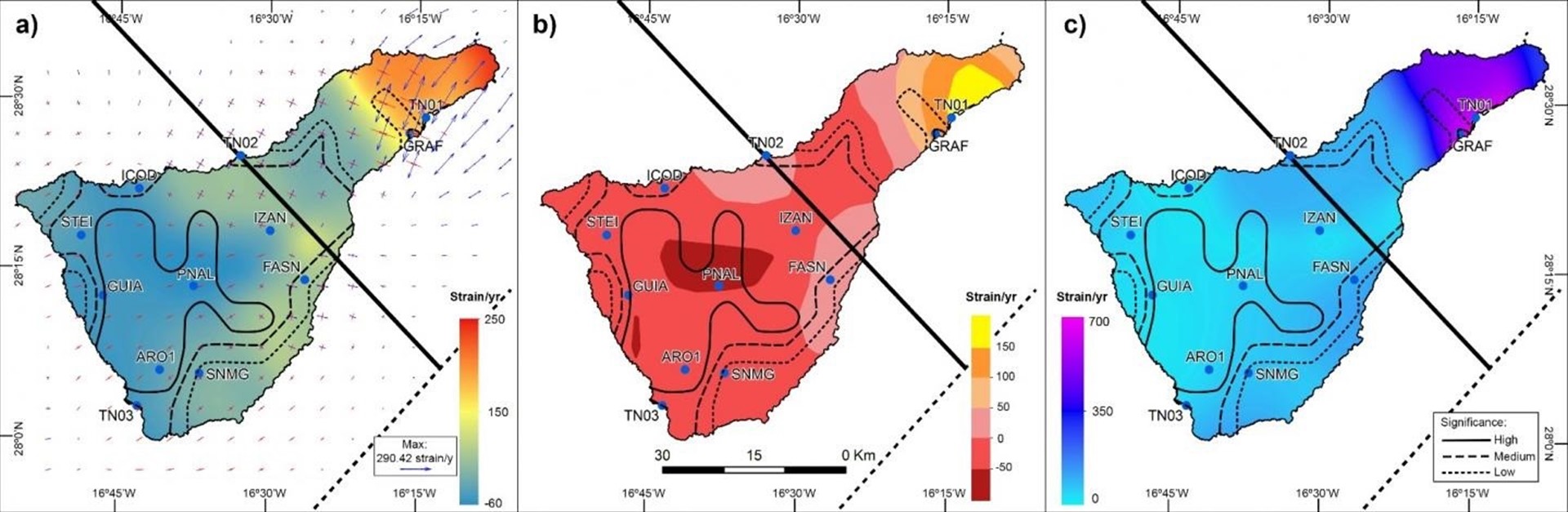
Map of the kinematic deformation of Tenerife (expansion in red and compression in blue). Image: University of Seville. Click on the image to enlarge.
Experts from the University of Seville and the Laboratory of Astronomy, Geodesy and Cartography of the University of Cádiz have published a study in which they analyze the behavior of the geodynamic zone of the island of Tenerife.
Although the objective of the study was not the behavior between the two islands, it has been observed that there is a process of rapprochement between Tenerife and Gran Canaria that could be caused by the action of an existing fault between the two islands.
"The displacement values between plates detected between the island of Tenerife and Gran Canaria are millimeter, so given the distance between the islands (approximately 64 km today), it will take millions of years, which could be due to a possible The movements are latent and there could also be new elements to be taken into account ", emphasizes the professor of the University of Seville, Cristina Torrecillas, in a statement.
In structural geology, the shear to which the researcher refers is the effort (force applied to a determined area of rock) by which forces act in parallel but in opposite directions, which results in deformation by displacement as long of closely spaced planes.
What is now a reality is that there is a gravitational collapse or isostatic adjustment of the Teide after the volcanic crisis of 2004, which registered about 230 low intensity earthquakes, almost 10 times more than usual.
This phenomenon has been detected thanks to the data provided by the GPS stations located around the island of Tenerife, with millimeter values every year. On the other hand, it has also been observed that the fissure of the northeast is expanding, possibly due to the action of a secondary fault that isolates the Anaga mountain range, in the central part of the island.
After the Teide volcanic crisis in 2004, caused by a multitude of not very intense earthquakes, the need arose to control the geodynamics of the island of Tenerife, so that initially seven reference points were established distributed around the island.
Two of these points have been configured in constant observation mode and the rest in periodic annual campaigns. Since 2008, other public bodies have implemented seven new reference points, with observation stations for continuous public access. Together, these two networks are known as the TEGETEIDE GNSS network, and it was the data from these two networks that were used to develop this study.
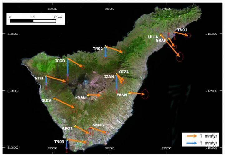
Horizontal annual interplate speeds (orange arrows) and annual vertical speeds (blue arrows) between 2005 and 2015 with a degree of reliability of 95 percent (ellipses and red holes). Image: University of Seville. Click on the image to enlarge.
Two geodynamic processes
The data collected by the TEGETEIDE GNSS network indicate a different vector displacement pattern, both in magnitude and in direction, which could be expected from the movement of the African plate, which covers the African continent and extends westward to the mid-Atlantic ridge.
These indications suggest that there is another process on the island of Tenerife that contributes to geodynamics not only by tectonic action, but also derived from volcanic activity.
"Volcanology is a complex and multidisciplinary science, but it is more than proven that the deformation of the surface in active zones generally preceded seismic or volcanic events, this technique has been applied in the case of the recent eruption on the neighboring island of El Iron, but it was not until 2015 that a study was published in the journal Science on predictive action with magmatic intrusions, "explains the researcher.
The researchers conclude in their article that the speed of the residual plate that indicates the movement of Tenerife towards Gran Canaria should be studied in the context of the entire Canary archipelago.
Interesting post you got here! I only want to suggest you to add sources you used to write this article and credit the images to who they come from. This would greatly benefit the credibility of your post. Then even @SteemStem, or @Geopolis (for earth sciences) might support your writing!
They have a great guide on how to structure scientific content properly:
https://steemit.com/steemstem/@steemstem/helpful-guidelines-for-crafting-steemstem-content
I hope this helps 👍
thank you, I will take the advice, from now on I will document the publications and I will give the credit to the photographs...