Let's talk -a little-about GIS !
A geographic information system (GIS) is critical to any utility’s business. A successful GIS will store and map a vast amount of information about the utility's electric and water systems, as well as outside plants.
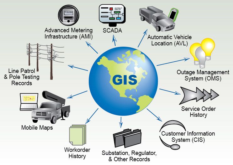
For maximum success, your GIS should become an integrated application at the utility. Many business processes or systems are impacted by and dependent upon a reliable GIS, including field design or staking, outage management systems (OMS), outage management prediction, line personnel maps, electric system modeling, inventory systems, asset accounting etc.
GIS can use any information that includes location. The location can be expressed in many different ways, such as latitude and longitude, address, or ZIP code.
Many different types of information can be compared and contrasted using GIS. The system can include data about people, such as population, income, or education level. It can include information about the landscape, such as the location of streams, different kinds of vegetation, and different kinds of soil. It can include information about the sites of factories, farms, and schools; or storm drains, roads, and electric power lines.
I'm sure that there is no limit to the kind of information that can be analyzed using GIS system!!!!
Sources:
.jpg)
http://www.powersystem.org/mapping-and-gis
https://www.nationalgeographic.org
@originalworks
Source: http://www.powersystem.org/mapping-and-gis
Not indicating that the content you copy/paste is not your original work could be seen as plagiarism.
Some tips to share content and add value:
Repeated plagiarized posts are considered spam. Spam is discouraged by the community, and may result in action from the cheetah bot.
Creative Commons: If you are posting content under a Creative Commons license, please attribute and link according to the specific license. If you are posting content under CC0 or Public Domain please consider noting that at the end of your post.
If you are actually the original author, please do reply to let us know!
Thank You!
More Info: Abuse Guide - 2017.
The @OriginalWorks bot has determined this post by @kater to be original material and upvoted it!
To call @OriginalWorks, simply reply to any post with @originalworks or !originalworks in your message!
Very Good step, More need to done in enlightening people on the usefulness of integrating the use of GIS into their businesses. Many view GIS as a complex tool that can only be used by big organizations/corporations, this have to change.
i'm totally agree with you :)