This is Mars observed the other way around

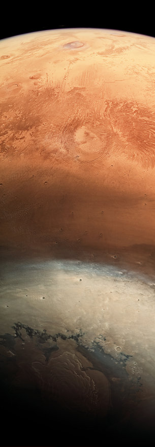
In space, what is above and below? The planets are usually shown with the north pole at the top and the south pole at the bottom, but in this striking image taken by ESA's Mars Express probe, we see the north of the Red Planet below and the equator at the top.
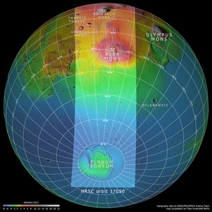
The image was captured on June 19 as the High Resolution Stereo Camera was calibrated and Mars Express flew over the planet from north to south. The nine camera channels - one downward-facing, four color and four stereo channels - swept the surface to record a large area with homogeneous lighting conditions. At the same time, the camera moved toward the horizon, rather than simply pointing to the surface as in routine images.
The result is this unusual wide-angle image of the planet, with the horizon illuminated near the equator at the top of the image and the North Pole shadowed at the bottom.
The northern polar cap was composed of water ice and dust at the time of capture, in early spring. The carbon dioxide ice in winter had already evaporated from the solid to the gaseous state. Water ice evaporates equally, injecting a large amount of water into the atmosphere, which circulates southward in atmospheric movements. When the seasons change again, carbon dioxide freezes and water ice is formed.
Looking south, the image shows some of the most important volcanoes in the Tharsis region. It covers an area larger than that of Europe and rises about 5 km above the average elevation of the planet, with volcanoes reaching 10-22 km high.

The biggest of the volcanic giants, Olympus Mons, does not appear in this scene and yields the protagonism to Alba Mons who, with a diameter of more than 1,000 km, stands out in the upper half of the image.
Alba Mons is on the margins of the Tharsis elevation and around it a series of parallel lines can be seen whose formation is due to the tectonic forces of the Tharsis bulge. As the region flooded with magma during the planet's first billion years of history, the crust spread. Later, while the subsurface magma chambers were discharged, subsidence of the crust also generated fractures.
If we continue towards the horizon, we will find Ascraeus Mons, 15 km high, this time covered by dense clouds. Several tens of kilometres above the horizon are also visible thin layers of clouds.

To the left of Ascraeus Mons are other volcanoes, such as Uranius Mons, Ceraunius Tholus and Tharsis Tholus.
Although of medium size for Martian standards, with diameters between 60 and 150 km, and heights between 5 km and 8 km above the surrounding terrain, rival many of the terrestrial volcanoes: the Mauna Kea is the highest volcano on Earth, with 10 km from the ocean base to the top, and just 4,200 m above sea level.
Hi, I found some acronyms/abbreviations in this post. This is how they expand: