Beautiful Satellite Images of our Planet you won’t believe are real #3
In my job at the European Space Agency, we look at what satellites can do for non-space sectors of society. Sometimes, however, you simply have to stop what you do and enjoy the majestic beauty of some of the images we get!
I have long believed that our satellites and telescopes deserve an award for the artistic beauty of their images. Here are 3 of my favourites from recent months together with a short description of what you are seeing. I hope you will enjoy!
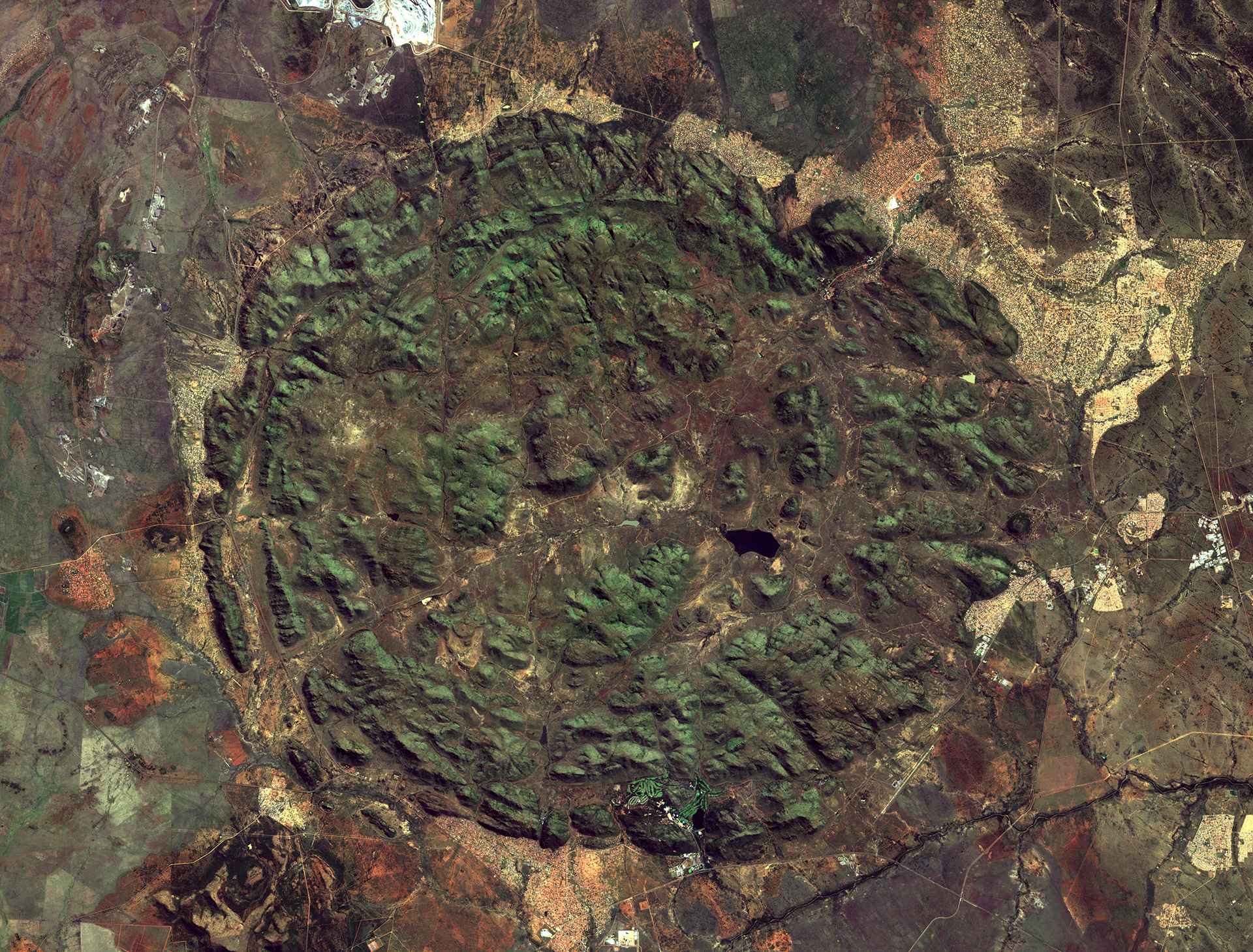
Pilanesberg, South Africa

The Pilanesberg natural park in north-western South Africa
image credit: ESA
The Pilanesberg Natural Park can be seen as a giant green circle in the middle of this 10 meter-resolution satellite image. It is a stunning feature of nature to produce such a giant symmetric shape in the landscape. As can be seen, the park is a preserved area from the surrounding villages and farmlands. The shape of the park was formed more than a billion years ago as the remnant of a massive volcanic complex. The volcano once towered over 7000 meters tall, a few hundred meters taller than the highest volcano today which is Mauna Kea at 6893 meters tall. The entire landscape bear the sign of the erosion of the old volcano over millions of years. Resulting in the almost perfect circular shape and the rings of hills rising from the surrounding plain. The diameter of the circle making up the park is roughly 25 kilometres.
The water bodies inside the park are not easily seen in this image, as they appear very dark. This is because these inland lakes are so clean that there is very little to absorb and reflect light back into space. As a result, they look almost black! The largest of these lakes is the Mankwe-lake near the centre. Before Pilanesberg became a natural park, this area was a water reserve used for agriculture. Farmers built a dam to create this lake, which today is not in use by the local population.
Pilanesberg is also the home to many exotic animals. These include the “big five”, namely lions, elephants, Cape buffalos, rhinoceros and leopards. The protected game reserve also includes animals like cheetahs, zebras, giraffes and more than 360 species of birds. The land outside Pilanesberg is speckled by infrastructures such as buildings, roads and even a football stadium (upper right).
Other structures seen in the image outside of the inner circle includes a number of platinum mines. One can be seen as the bright area at the top of the image, as well as a smaller square area at the bottom. If you look closely, you can also spot a football-field in the city just north-west of the circle.
Kamchatka, Russia

The Kamchatka Peninsula in eastern Russia
image credit: ESA
Unlike all other images used in this series so far, this image is taken by the European Sentinel-3 satellite. Whereas the Sentinel 2 satellites capture optical images in 10 meter-resolution, the Sentinel 3’s main objective is to monitor atmospheric and oceanic changes over time. It thus offers a lower resolution of 300 meters to increase its scope.
This image takes us over the Sea of Okhotsk, next to the Kamchatka Peninsula in far-eastern Russia. Large portions of the peninsula can be seen on the right-hand side of the image where clouds blend with the ice and snow beneath from our bird’s eye view. Because this image is taken in February, most of the landscape is covered in snow.
One thing making this image so beautiful is the pattern of light blue versus dark blue seen in the ocean. The light blue colour is due to floating sea ice, reflecting more colour from the blue portion of the spectrum back into space, relative to the clear waters. To the left large cracks in the ice are seen as blue stripes in the otherwise white glacier. Along the east-side of the peninsula to the right, stripes of light blue are seen drifting with the wind away from land.
Several volcanoes covers the peninsula’s landscape due to its location along the highly active Pacific “Ring of Fire”. Roughly 160 volcanoes should be encapsulated in the image of the peninsula. Out of which 29 are still active. In the centre of the peninsula, we can see part of the central mountain range running down its spine. Whereas most of the eastern range is covered by clouds. Between them lies the central valley, appearing somewhat brown from the lack of snow cover.
Considering the number of volcanoes, and the amount of ice and snow, it is perhaps no surprise that the area is often referred to as the “land of fire and ice”. Perhaps an ideal location for some scenes in the final season of Game of Thrones?
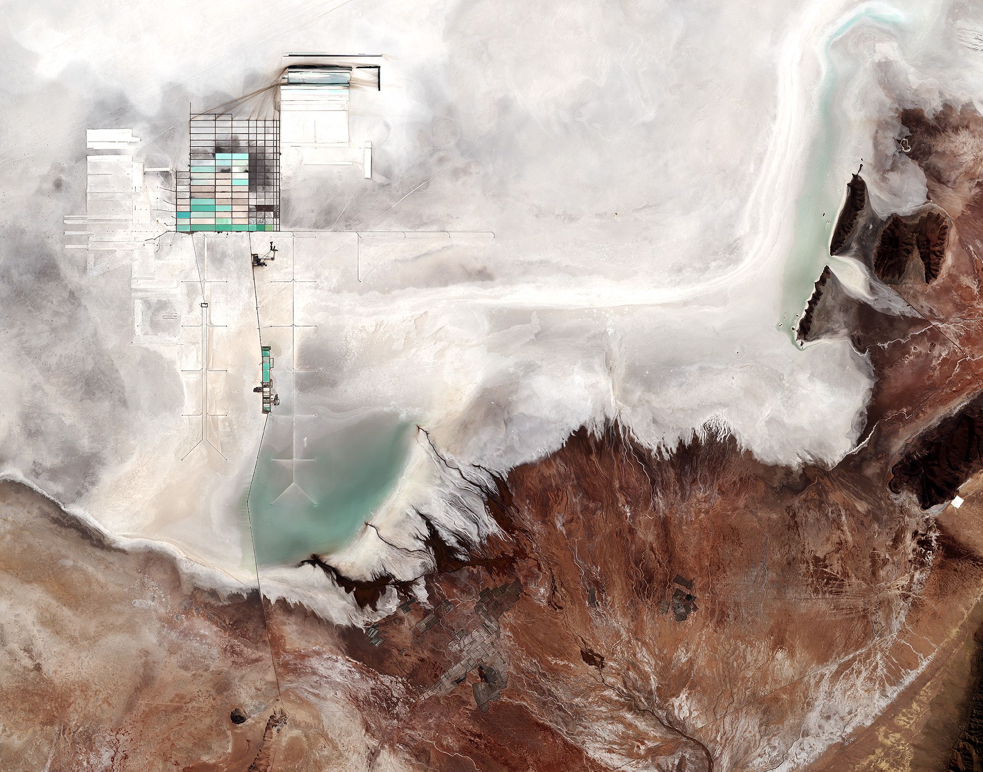
UYUNI SALT FLAT, BOLIVIA

The Salar de Uyuni salt flat in south-western Bolivia
image credit: ESA
This 10-meter resolution Sentinel 2 image shows part of Bolivia’s Salar de Uyuni, the largest salt flat in the world (I suggest having a look in google maps as it is really huge!) The salt flat covers no less than 10 000 square kilometres and lies at the southern end of the Altiplano, a high plain of inland drainage in the central Andes. The area was part of a gigantic prehistoric lake, which dried out roughly 40 000 years ago.
For generations, the local Aymara people have harvested the salt in this region. Perhaps more interesting from a modern day business perspective is the fact that the Uyuni flat also hosts one of the richest lithium deposits in the world, with an estimated volume of 9 million tonnes.
To the upper left portion of the image, you can see large evaporation ponds for the local lithium plant as large grey and light blue rectangles. Here, lithium bicarbonate is isolated from salt brine. With the increasing demand for batteries to power electric cars, the value of lithium deposits such as these is continuously increasing. Making it an interesting resource to monitor.
The Salar de Uyuni is very flat, with a surface elevation variation of less than one meter. The surrounding terrain is rough in comparison, with a 20-kilometre wide alluvial fan of the Rio Grande de Lípez delta visible in the lower left.
BONUS IMAGE: Algae bloom in Lake Erie, northern US and southern Canada

Image of an Algae bloom in Lake Erie stretching across several northern states in the US as well as the south of Canada
Image credit: NASA Earth Observatory
In yesterday’s post, 3 Amazing things we can now do with satellites #2, I showed an interesting use-case of satellites to monitor the state of algae blooms in inland lakes. As it happens, images of algae blooms are really beautiful! A bit like watching an aurora in the sky. I highly recommend viewing the full-scale image to fully enjoy the resolution of these images and the deep insights they provide. A more detailed explanation of what you are seeing in the image can be found in the link.
Want to try processing new satellite images yourself?
All the main images above were taken by the European Sentinel satellites. The image processing has been done by ESA, the European Space Agency. You can download the raw data from their satellite constellation yourself for free here, which can be processed professionally by the free and open source tool snap.
I hope to share more of these breathtaking images and continue making it a regular theme for my steemit blog. If there are parts of the world (perhaps where you live) you want to see an image of please let me know and I’ll dig it up!
Fredrik / @fredrikaa
These are wonder pictures, i shared interest in space science because one of my collaborators is a space scientist. I look forward to more insightful images.
Happy that you enjoy them :)
Amazing views and as always your posts are so worth reading 📖 ...
Thanks a lot @orlena :)
I really love your posts. You're kind of like my steemit Carl Sagan. Your posts re-invigorate me with wonder and awe of the earth. And now I've put Pilanesberg on my list of places to visit.
Wow, thank you @travelman ! Considering how much of a hero and inspiration Carl was to me that really is the highest level of a compliment I have ever received! So thank you very much for saying that :)
Very happy that you have enjoyed my posts so far, and hope I can continue to give value to you!
Here in the Eastern US we are trying to reintroduce chestnut trees after they were almost completely killed off by a blight. The project involves finding survivor stock in the wild and crossing it with a line of hybrid trees that were selected for blight resistance. The survivor trees are usually small, hard to see, and deep in the forest, but they hold their leaves and stay green later into the Autumn than other types of trees. Do you think you could find photos of central Pennsylvania in the September and October when most trees are turning red, yellow, and orange? We would need to look for patches of deciduous trees that are still green. They would probably be on hilltops in dense forest.
That should be doable :)
Really cool images from above, I might have to start playing around with snap.
I always like looking at satellite images so I am following you.
Me too! They are truly beautiful :)
i love satellite images...=D
Me too! :)
Awesome again with the extra in depth info. The first natural park felt so much smaller until you pointed out the mines and structures! eesh
Happy you enjoy that bit, it's the most time consuming after all :P
Yeah, you don't think about the fact that there are houses in the image. But then it's like "oh, wait a second!"
This post has been ranked within the top 50 most undervalued posts in the second half of Jul 25. We estimate that this post is undervalued by $16.14 as compared to a scenario in which every voter had an equal say.
See the full rankings and details in The Daily Tribune: Jul 25 - Part II. You can also read about some of our methodology, data analysis and technical details in our initial post.
If you are the author and would prefer not to receive these comments, simply reply "Stop" to this comment.
Amazing !!