Using Geographic Information System (GIS) to create accurate 3D topografic simulations
Living in an ever changing world, the time for performing local development policies or just thinking about a complex environmental situation with a couple of other people is not sufficient to get the insight needed. The technological advancement are so great that now you can use a specialized suite of software and simulation solutions to get the most out of any civil development or engineering project. From designing highways, to accurately predicting the traffic flow between various city areas, the Geographic Information System or GIS can help a lot.
I am not going to get into what GIS is, as another steemSTEM author, @langford, described it here.
While GIS is not a new system and is being used for quite a while, it has gained significant used due to the increase of the mapping resolutions of the newly launched satellites.

Resolution and accuracy
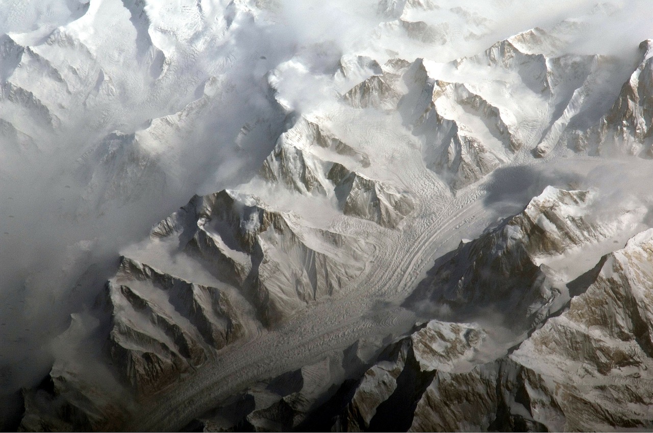
Having to rely on Geospatial Data Sources, you must take into account that the orbit of such a satellite is significantly far from the actual mapping location. For example, the SENTINEL-2 (A and B) are both on sun-synchronous orbits, which means that the images they take have the exact same illumination. Their orbit is at 786 km above the ground so you need to keep in mind that the optics needed for that satellite to accurately map the ground needs to be very good.
How do you measure the accuracy of something that is far away? It seems that by zooming in to your target you can measure the angle of the view, in degrees and in its subdivisions, arcminutes (1/60 of a degree) or arcseconds (1/3600 of a degree).

Source
The lowest the mapping angle, the narrower the area of the capture and the highest the resolution, which is also helped by a very fast and dense image sensor.
In time better and better resolutions came to the market, starting from 60 arcsec and down to 3 arcsec and even 1 arcsec in the last few decades. The most notable are the GLOBE and GTOPO30, both operating at 30 arcsec and CGIAR using the data from the famous Shuttle Radar Topographic Mission. The data is mostly available in 1 arcsec but there are zones that are only covered in 3 arcsec resolution. This basically means that most of the world is covered by imagery in which one pixel is 30 meters, in the public domain. The public sector such as DigitalGlobe and other suppliers have even more detailed information possibly down to the 30 centimeters of accuracy (1 pixel is 30 centimeters). You can spot a cat or your lost android tablet from space. And we are not even discussing the military missions.
How can you use this data?
Either commercially through the use of specialized software, or through the use of open-source applications and public domain data. This ensures that everybody can get their hands on the data, in a pretty simple way.
If some years ago the data from CGIAR and SRTM v2 were publicly available from Ambiotek at http://www.ambiotek.com/topoview (which can be used to overlay a KML on Google Earth), because of the huge amount of bandwidth requirements, it was lately discontinued or simply unavailable. But there are other ways to get your hands on the data
Come into play USGS - United States Geological Survey
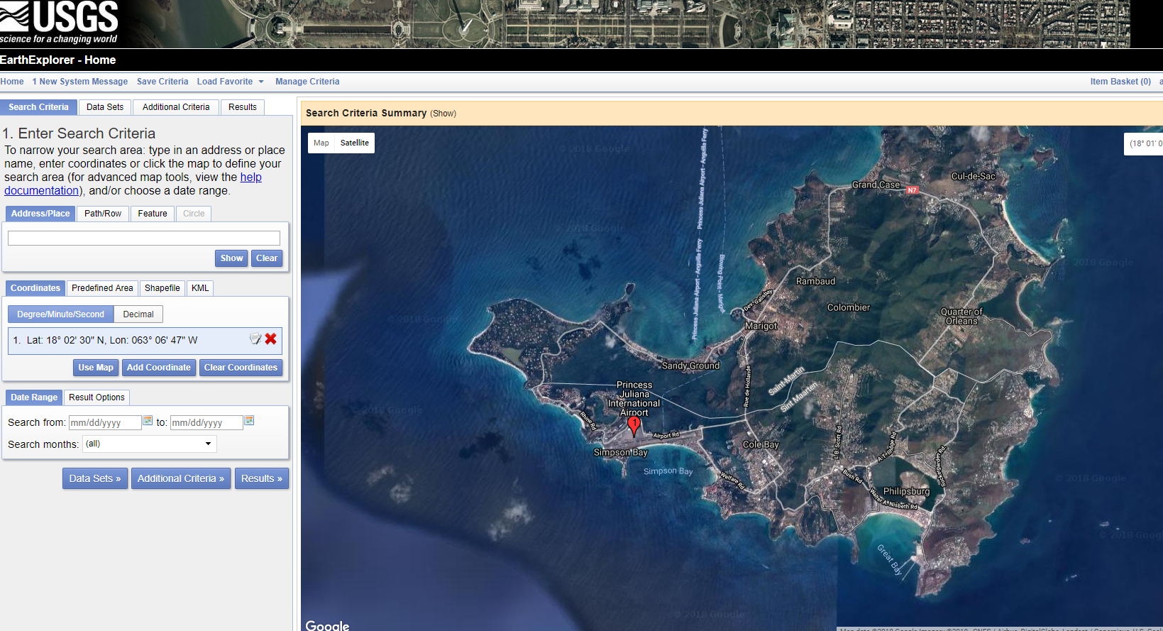
By using the data in the public domain they facilitate the acquisition of the data in a very intuitive way. You can use their web application Earth Explorer, which is a little Google Maps on steroids, you can select and zoom on the globe to select your desired area of interest.
You have a lot of filters and data sets to choose from and you can search for the data set which helps you the most, from Declassified Data to Digital Maps, radar maps, vegetation monitoring and so on. By using custom KML files(Keyhole Markup Language), a standard of the Open Geospatial Consortium and of the industry it seems, you can add your own data sets and export them or import them in Google Earth.
Nice piece of trivia is the fact that before Google Earth was bought by Google it was developed by Keyhole. I still remember installing it for the first time and saying that it will change the world.
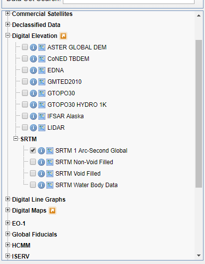
Let's say that I want to create an airport simulation and I would like to give the controllers the possibility to train in the most realistic way, by having the terrain features simulated in an accurate way; I just need to power up Earth Explorer from https://earthexplorer.usgs.gov/, select the area and the dataset - pictured in right - the SRTM 1 Arc-Second Global, which is the best source for digital elevation acquisition, and select any additional criteria I would have and download it.
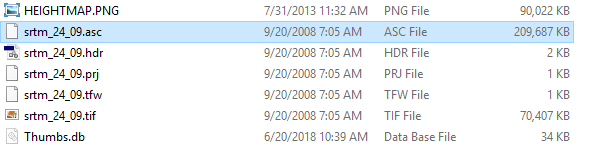
The result can be downloaded in one or more formats. If you need to analyze the data in another comprehensive way you could download the data as vector or in raw format, or you could download the GeoTIFF, which is a special variation of the TIFF file type, including coordinates and other data, very helpful for some projects.
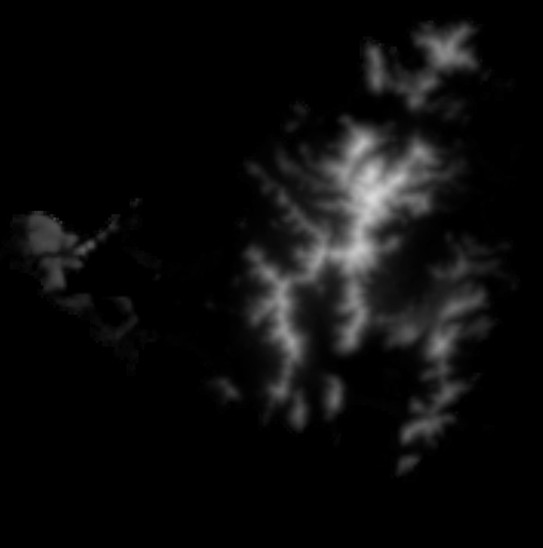
Then, either by using another free software such as Microdem, pictured below, or directly importing it into Photoshop or another image editing program such as GIMP, you can generate a heightmap of it. If the data source is in ASCII format, a software such a Microdem can pull the topographic data easily, without any quality loss, which is preferred if the accuracy is of the highest importance.
The software has a lot of other options, someone invested in GIS could really lose a few weeks in this software, I am not an expert so I don't know or use the full range of filters and settings.
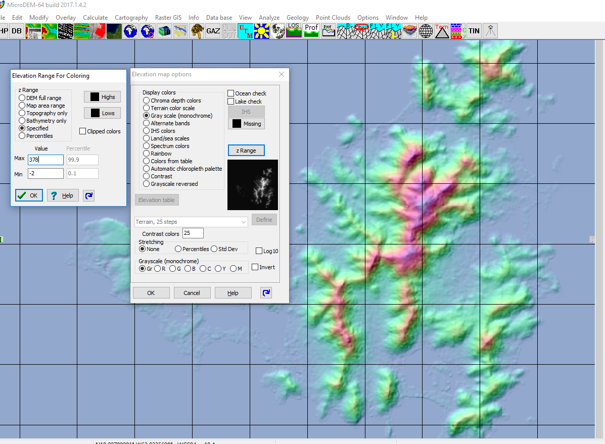
Selected area AND the automatic generation of the heightmap by using the real altitude from the data sets. The output file also needs to support bit depth in order to keep the full range of the details. You can see the heightmap in black and white in the window as a preview.
Using the data in your own projects
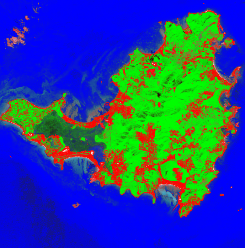
We have identified the height data and by analyzing the colors of the terrain we came with a pretty realistic identification of the water in blue, vegetation in green and the other surfaces, mainly dirt, tarmac and sand in red. Further coloring is done in Adobe Photoshop to make the transitions smooth and we are ready to incorporate it in our application.
By using a 3D Modeling application such as Autodesk 3ds max or Blender (open source), you can then integrate the data in your own scene. You can blend the heightmap with the colored helper and the satellite image, all from the public domain. The imported height-map and the height data makes sure to always maintain the highest accuracy of your simulation.
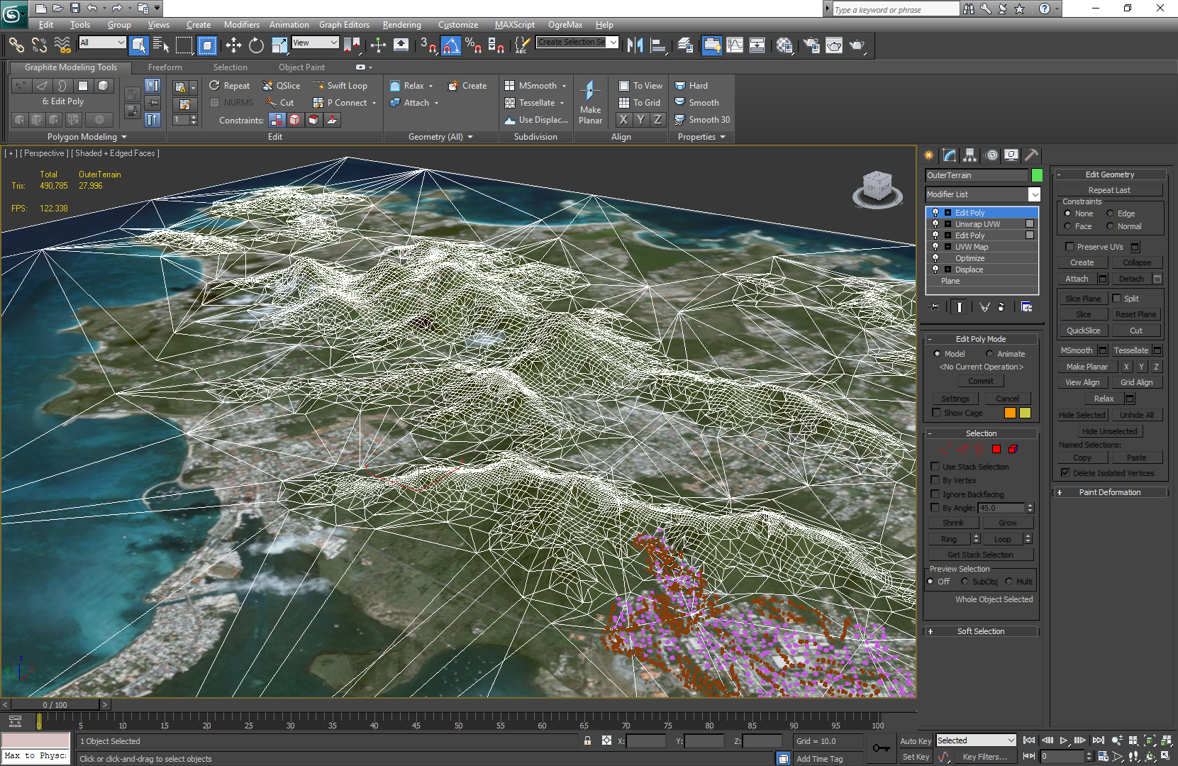
The end result of the data being imported into a 3D modeling software. The mesh can be altered or built upon, optimized for real time simulation software or enhanced for animation purposes.
This is just an example but the power of GIS and satellite imagery is huge
Designing bike lanes, organic city development, animal migration and much more I can't even wrap my head around are all possible and I would actually like to see the government making more use of the tools they have. I know that it's more complicated than not doing it, but such is the science. We have reached a point beyond what only the simple optimistic thoughts would be enough for us and I would like to see more attention to it.
Sources and further reading:
https://www.usna.edu/Users/oceano/pguth/website/microdem/microdem.htm
https://en.wikipedia.org/wiki/Topographic_map
https://en.wikipedia.org/wiki/Digital_elevation_model
https://en.wikipedia.org/wiki/Digital_elevation_model#/media/File:Moon_elevation.stl
^^^ click this one ^_^
https://lta.cr.usgs.gov/sentinel_2
https://www.digitalglobe.com/products/digitalglobe-basemap
https://www.ngdc.noaa.gov/mgg/topo/report/s11/s11G.html - another guide to import data in your application, using different software. 
Contribute STEM content using the #steemstem tag | Support SteemSTEM authors | Join our curation trail | Visit our Discord community | Delegate SP to SteemSTEM
I wish they would use that to make more realistic CIV game maps :D
Or maybe they already do: your USGS map looks pretty similar to the ones in those games.
Heck, I'm inspired to do some of my own designing after reading this:
:P
Lol. Whatever Screams steemSTEM off the rooftops is perfect!
You can download fan-made maps for CIV :D They are usually very detailed and nice, well, at least those that strive to be..
I didn't have time to play in like ages, I would usually play with my GF, she starts all the wars and I protect her with my military as she doesn't like to research or build military units, while I have a hard time keeping the upkeep low :)
If I am playing alone, I specifically try to avoid building any military. Sometimes Gandhi attacks me with nukes but we all know that
https://kotaku.com/why-gandhi-is-such-an-asshole-in-civilization-1653818245 :)
😂
Man I wasted so many summers on CIV, don't remind me ... :D
A nice read @alexdory, keep up the great work.
Agreed, this application is a total beast. Enables the user to do so many different things, USGS ftw.
I didn't know about Microdem though so I will have to do my research. Thanks for the info!
It's an old app that I have used for 10 years :)
Made by a naval military organisation or such, in 1996, updated ever since. Very good app.
GIS is indeed a wonderful field! Especially since the possibilities, and available data is getting increasingly larger. Another great tool for accessing and using publicly available data is the Google Earth Engine. It offers many of the publicly available datasets and is a cloud computing platform, meaning you do not have to download any data or run any code! Amazing isn't it? I have written some posts and papers about it and I'm currently working on a tutorial series about it.
https://earthengine.google.com/
Amazing! I really should read them, I am actually working with GIS in my airport project. Took me a great deal of research to come up with the tools a few years ago but I am open to see what the new software might bring to the equation. Thanks for the tip, I am signing up now! I will also read your tutorials on it, really curious about the tools.
You received a 60.0% upvote since you are a member of geopolis and wrote in the category of "geopolis".
To read more about us and what we do, click here.
https://steemit.com/geopolis/@geopolis/geopolis-the-community-for-global-sciences-update-4
Thanks, I knew you would like it :P
And I have learned something new in the process!
Hi @alexdory!
Your post was upvoted by utopian.io in cooperation with steemstem - supporting knowledge, innovation and technological advancement on the Steem Blockchain.
Contribute to Open Source with utopian.io
Learn how to contribute on our website and join the new open source economy.
Want to chat? Join the Utopian Community on Discord https://discord.gg/h52nFrV
Congratulations @alexdory! You have completed some achievement on Steemit and have been rewarded with new badge(s) :
Click on the badge to view your Board of Honor.
If you no longer want to receive notifications, reply to this comment with the word
STOPDo not miss the last post from @steemitboard!
Participate in the SteemitBoard World Cup Contest!
Collect World Cup badges and win free SBD
Support the Gold Sponsors of the contest: @good-karma and @lukestokes
Hi @alexdory!!
How are you bro? Sorry, I am so late in commenting!!
Loved your article bro!! Thank you so much for this good read. :)
I agree to this!! You did a very good thing mentioning about it. :)
Wow bro!! It is so amazing in the pictures you provided.. Enjoyed reading your article a lot!
Thanks for bringing up this post!! It is so enjoyable in reading!!
Wishing you a very happy time ahead bro!! :)
A well done article as I always see on your blog .
Thanks!
Congratulations @alexdory! You have completed the following achievement on Steemit and have been rewarded with new badge(s) :
Click on the badge to view your Board of Honor.
If you no longer want to receive notifications, reply to this comment with the word
STOPDo not miss the last post from @steemitboard:
SteemitBoard World Cup Contest - France vs Belgium
Participate in the SteemitBoard World Cup Contest!
Collect World Cup badges and win free SBD
Support the Gold Sponsors of the contest: @good-karma and @lukestokes
I am greatly impressed by this post even though my comment is coming very late. I had to bookmark this page, so that i can read again and digest further.
By the way, i use ArcGis software for most of my GIS projects. Also i have used USGS Earth explorer often. I enjoy it for its simplicity unlike other sources.
For my topographic maps, i use the spatial analyst tool in Arcmap ( slope,hill shade e.t.c ) to analyse.
Where can i get more GIS related articles on steemit. Thank you.